This is another section from the book regarding some geography relative to the family.
A
Brief Lower Eastern Shore Geography Lesson
The Lower Eastern Shore encompasses the Maryland
counties of Caroline, Dorchester, Wicomico, Worcester and Somerset; Sussex
County in Delaware; and Accomac and Northampton Counties in Virginia.
Since the founding of these counties, their boundaries have varied quite
significantly.
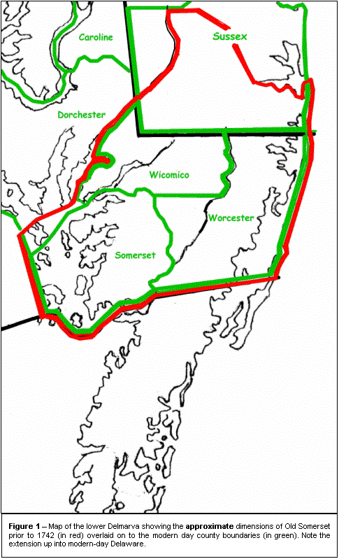
Old Somerset, founded in 1666, was the original
county on the lower Eastern Shore of Maryland.
As shown, it was bounded to the west by the Chesapeake Bay and up the
Nanticoke River to about modern-day Bridgeville, to the east by the Atlantic
Ocean, to the south by the Virginia line (though this was disputed for a time)
and to the north by a line extending from the Nanticoke River eastward to a line
roughly from Georgetown to Millsboro and down to the modern Delaware-Maryland
state line.. This includes the
cities of Salisbury, Princess Anne, Snow Hill in Maryland and Laurel, Delaware.
Figure 1 illustrates the
approximate boundaries of “Old Somerset” overlaid on to the modern-day
county map as it existed prior to 1742.
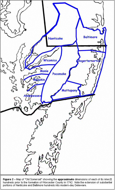
Old Somerset also was comprised of nine (9)
sub-units known as the “hundreds.” Their
names were: Nanticoke, Wicomico,
Pocomoke, Monie, Manokin, Annemessex, Baltimore, Bogerternorton, and Mattapany;
the last three having been formed at a later date than the others.
The hundreds basically were political subsets of the county that had
their own constables (who collected taxes) and overseers of the roads (assigned
to maintain the roads, bridges and ferries).
Figure 2 illustrates the rough boundaries of the hundreds of Old
Somerset.
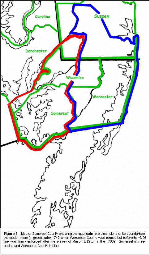
In 1742, Worcester County was formed by splitting
Old Somerset roughly in half on a north-south dividing line.
This dividing line extended from about Laurel, Delaware in the north
continuing south through the heart of Salisbury, Maryland
.
It extended further to the south through modern Fruitland, Maryland and
further south along an ancient road from Fruitland to Princess Anne until it
picked up Dividing Creek. Dividing
Creek became the boundary until it empties into the Pocomoke River where it was
the boundary down to the Virginia line. Snow
Hill became the county seat of Worcester.
More notably, the northern boundary of Somerset was
then defined along the Nanticoke River only as far north as Broad Creek to a
line extending eastward roughly to the Indian River inlet in modern-day
Delaware. All of “Old Somerset”
north of Broad Creek became part of Worcester County after 1742.
Thus, after 1742, Somerset County roughly looked like the RED-oulined
area on the map in Figure 3 and
Worcester looked like the area outlined in BLUE.
In the 1760s, Old Somerset was further reduced in
size when Charles Mason and Jeremiah Dixon conducted their famous survey to
finalize the boundary between Maryland and Pennsylvania/Delaware as a result of
the transpeninsular survey of 1750. The
survey shaved about a 7-to-10 mile wide strip of land from the northern side of
the old county (it also shaved a good chunk of land from the eastern side of
Dorchester and Caroline Counties – from the Nanticoke River west to the new
state line).
In 1867, the loss of land to Old Somerset was made
final by the formation of Wicomico County.
Wicomico took roughly equal portions of land area from Somerset and
Worcester Counties. Worcester lost
its land in its northwest quadrant and Somerset from its northern third –
about from Wicomico Creek in the south to the Nanticoke River and Delaware line
in the north. Salisbury was
relieved of its dual-county personality split between Somerset and Worcester and
made county seat of the new Wicomico County.
All these different and changing boundaries for the
states, counties and hundreds, makes for a difficult task for the researcher to
find his ancestors in the old records – especially when they were domiciled
near one of these old borders. Adam
Hitch and his descendants seemed to have a propensity for settling near borders
thus elevating my frustrations! To
track many of these folks, I was obliged to search records in Maryland for
Somerset, Worcester, Wicomico, Dorchester and Caroline Counties as well as
Sussex and Kent Counties in Delaware. Even
contemporay sources may have one record listed in one county and another in the
adjacent county.
One example of this is my 5x great grandfather
Benjamin Hitch (1738/1740 – 1814) and grandson of Adam through Samuel Hitch.
Ol’ Benny purchased 150 acres of land from George Wilson in 1764 called
“Mount Pleasant
” situated – you guessed it – on the border
between Somerset and Worcester Counties, “lying near the head of the main
branch of Wicomico Creek.” Today,
this land lies near the boundaries of the three counties (with Wicomico
included). In 1770, Ben sold
off 50 acres of the tract to Thomas Price and the records describe it as land
that was "then situated in Somerset, now part in Worcester part in
Somerset." The next mention of
the land in records is in the Maryland Tax Assessment of 1783 where “Mount
Pleasant
” fully attributed to Somerset County.
The same is true in the Somerset County Assessment Records for the years
1793 through 1796.
In the Federal Assessment of 1798, Benjamin Hitch
is shown as owner/occupant of the tract in Somerset County but "…situated
on the road that divides Somerset from Worcester…”
The Somerset County Commissioners of the Tax Report verify the location
of the land in Somerset for the years 1798 through 1803.
During this time, Ben Hitch subdivided “Mount Pleasant
”
further by selling 50 acres to his son Joseph in 1800.
Joseph subsequently moved to Pendleton County, KY in 1807 and sold his
portion of “Mount Pleasant
” to brother John Hitch in 1809.
By the time Ben bequeathed the final portion of the
tract to son Samuel through his will in 1814, the land was again described as
divided between the two counties, “to my youngest son Samuel Hitch
, plantation I now dwell 50 acres part in Worcester
County
and
part in Somerset County
."
The land passes on to Samuel Hitch’s son Handy Irving Hitch in 1848
through WORCESTER County records. From
then until the time the land passed from the family by auction of Handy’s
estate in 1901, it was considered to be fully in Worcester County.
By this example, one can see that, although
this land was purchased in Somerset County in 1764 – and obviously did not
move – it was variously attributed to Somerset, Worcester and a combination of
the two over the years. This makes
for a difficult study for a researcher into this line.
Numerous other examples of Hitch property can be cited that faced similar
confusion over the years, therefore, any research that might follow this work
should take this into very careful consideration.
However, one should not be discouraged into not reviewing the land
records as they can offer excellent insight into the family and various kinships
as demonstrated in the following paragraphs.
|
 |
Adam Hitch and his Descendants in Maryland and Delaware
Adam Hitch first shows up in Maryland with the
ownership of a land tract called “Beaver Dams” in 1687 which he bought from
William Jones Jr. After this, Adam
Hitch dealt in quite few large land transactions during his lifetime.
A summary of Adam’s extensive land holdings in the late 17th
and early 18th centuries follow:
|
TRACT |
LOCATION |
PURCHASED |
SOLD/OTHER |
|
Beaver Dams: 300 acres |
Half of New Holland |
1687 |
1695? |
|
New Holland: 600 acres |
Six miles up the Wicomico
River |
1687 |
1695 |
|
Allerton 75 acres of 250 acre
“First Choice” tract on the Annamessex River
(from Wm Foxson) |
N/A |
1693 |
1705? |
|
Green Recantation: 200 acres |
Near the Nanticoke River and
north side of main branch of Quantico Creek |
1693? |
1709 |
|
High Suffolk
: 1,450 acres |
Headwaters of Wicomico River |
1700 |
Sold some to Francis Langake
(later Lank) and John Cordrey Jr. in 1721.
Dispensed some to heirs in 1728.
Willed rest to heirs in 1731. |
|
Come by Chance
: 563 acres |
South side of (20 poles
from) main/mill dam branch of Cottingham Creek (later Rockawalkin),
about 2 miles north of Wicomico River |
1707 (survey), 1721 (patent) |
Sold some to Francis Langake
(later Lank) and John Cordrey Jr. in 1721.
Dispensed to heirs in 1728. Willed rest to heirs in 1731 |
|
North Wales: 500 acres |
South side Nanticoke River |
1709 |
1719-1722? |
|
Faurtum:
50 acres |
N/A |
?? |
1714 |
From this, one can see that most tracts were
temporary – and maybe speculative - holdings with the exception of “High
Suffolk
” and “Come by Chance
.” It
is unknown where Adam Hitch lived until he purchased “High Suffolk
” in 1700 and “patented “Come by Chance
” in 1707. In
his will, Adam Hitch states, “…part of my dwelling plantation which is
included between Samuel Heatch
's land and the mill branch, with part of a tract
called "Come By Chance
",
and part of another tract called "High Suffolk
". This
suggests that the family residence was located on a portion of both tracts.
It is difficult to determine exactly where within
the “High Suffolk
”
or “Come by Chance
”
tracts Adam Hitch’s residence was located.
According to the records, a mill was definitely kept by Adam on the
“Come by Chance
”
increasing the possibility that it was the ultimately the place where Adam Hitch
built a home for his family and the words in his will seem to indicate that he
favored the “mill branch” facing spot.
Thus, the Adam Hitch house may be surmised to be located on or close to
the Rockawalkin Creek about two miles north of the Wicomico River.
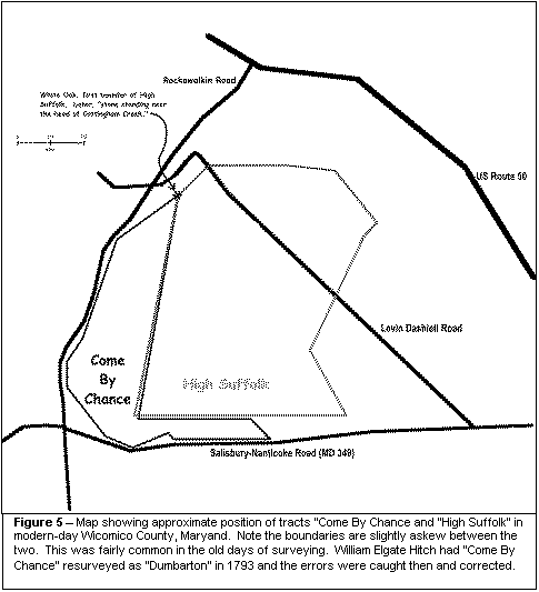
On a modern-day map, “Come by Chance ” can be located in Wicomico County bounded by the Salisbury-Nanticoke Road to the south, Rockawalking Creek to the west and the intersection of Levin Dashiell Road and Rockawalkin Roads to the north. The tracts then takes on the shape of a upright letter “L.” Figure 4 illustrates the location and shape of the “Come by Chance ” tract in BLUE outline.
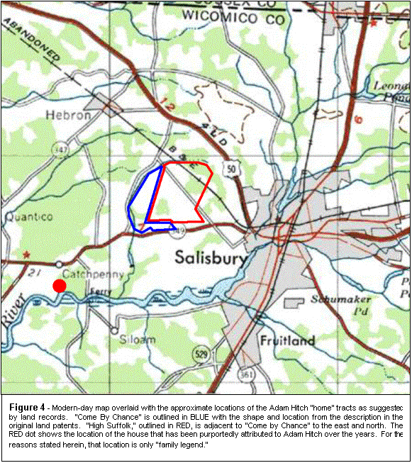 |
The reader is cautioned that there exists a belief
that the Adam Hitch house still stands on the north bank of the Wicomico River
today (2000) – in the Howard C. Hitch family.
That house is located on the north side of the Wicomico about 2 ˝ miles
west of where Rockawalkin Creek empties into it. This is approximately 3 miles southwest of the closest
portion of the location of the tract “Come by Chance
.” See
Figure 4 for more details.
No evidence exists that shows that Adam Hitch even owned land at that
location during his lifetime and the “fact” that the
 house there today is that of Adam Hitch is just a
good example of family legend.
house there today is that of Adam Hitch is just a
good example of family legend.
By examining the land records closely, the
approximate divisions of “Come By Chance” and “High Suffolk” over the
years can be ascertained. Figure
5 shows a close-up of the two tracts as they would approximately appear on a
map of today and as they were prior to 1721 when Adam began selling off some of
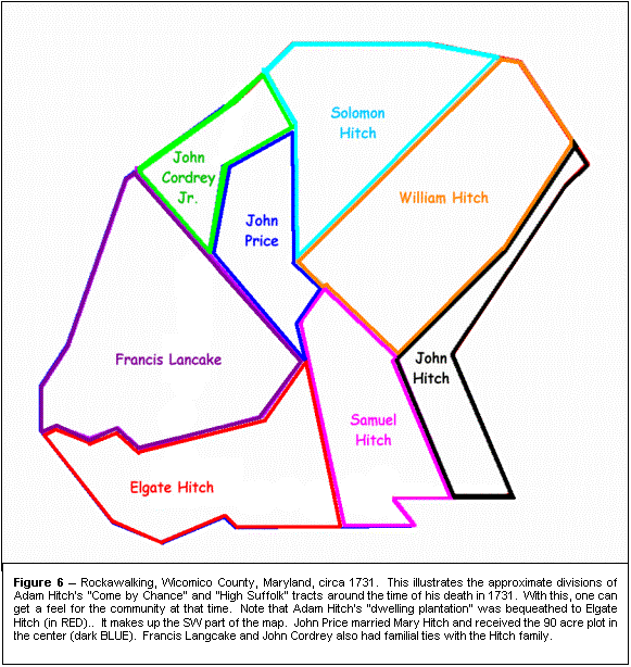
the land. Figure 6 illustrates the divisions of the two tracts at the time
Adam Hitch died in 1731. It
accounts for the following land transactions:
Adam Hitch’s male children received a substantial
legacy of land from both the “High Suffolk
” and “Come By Chance” tracts as “deeds of
gift” to Samuel, William, John and Solomon in 1728 and through his will to
Elgate Hitch in 1731. Adam also
bequeathed land to John Price, son of his daughter Mary Hitch Price.
Most of these transactions have metes and bounds laid out in the land
records (except the last two). From
that, I plotted the approximate configuration of the land in 1731.
This is shown in Figure 6.
Note, the layout in Figure
6 represents an approximate map of the local community in that area 270
years ago. Note that Adam Hitch’s
“dwelling plantation” was bequeathed to Elgate Hitch and contained his mill.
It makes up the SW part of the map.
John Price married Mary Hitch and received the 90 acre plot in the
center. Francis Langcake (later Lank) and John Cordrey also had familial ties
with the Hitch family as will be shown later in this volume.
It should also be noted that William Hitch died in 1730 – before Adam
Hitch died in 1731 but after his 1728 land allotment and his land was devised to
his four (4) sons viz, William (b. 1719), Thomas (b. 1720), John (b. 1722) and
Nehemiah Hitch (b. 1724) through his will. All were minors and Thomas Hitch died
before 1732 so his share of the land went to eldest brother William.
 |